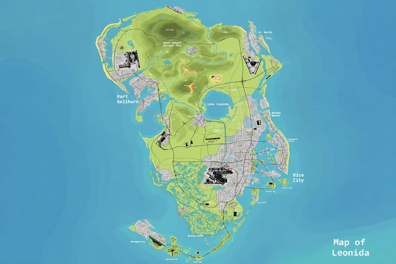
Leonida is the main setting of GTA 6, featuring six distinct regions: Vice City, Leonida Keys, Grassrivers, Port Gellhorn, Ambrosia, and Mount Kalaga National Park. Each area offers a different environment, from busy coastal streets and island roads to wetlands, industrial locations, and mountain trails.
Players preparing for GTA 6 Online Money should become familiar with Leonida’s geography before planning future activities. Understanding the main regions, recognizable landmarks, and available travel routes will make exploration more efficient. Online earning methods and business opportunities have not been fully detailed, so map preparation should focus on confirmed locations rather than assumed money-making routes.
Leonida’s Six Regions at a Glance
| Region | Environment | Exploration Focus |
|---|---|---|
| Vice City | Large coastal city | Urban landmarks and city navigation |
| Leonida Keys | Tropical island chain | Bridges and coastal exploration |
| Grassrivers | Wetlands and mangroves | Waterways and natural terrain |
| Port Gellhorn | Run-down coastal resort town | Local streets and abandoned attractions |
| Ambrosia | Industrial town | Sugar refinery and surrounding roads |
| Mount Kalaga National Park | Hills, rivers, and natural trails | Outdoor and off-road exploration |
These six regions have been introduced as parts of Leonida. Their exact boundaries, complete road connections, and travel distances should be verified in the finished game rather than estimated from fan-made maps.
Vice City: Explore the Main Urban Areas
Vice City is Leonida’s major urban center, featuring neon-lit streets, coastal neighborhoods, and commercial areas. Recognizable locations include Ocean Beach, Little Cuba, the Tisha-Wocka flea market, and VC Port.
For efficient exploration, focus on learning the main districts and their recognizable landmarks instead of trying to memorize every street immediately.
- Explore one district at a time to avoid repeatedly crossing the city.
- Pay attention to major intersections and roads connecting nearby neighborhoods.
- Remember recognizable landmarks when traveling between destinations.
- Choose a vehicle with predictable handling for crowded streets.
When traveling to a mission location, identify the surrounding area before approaching the objective. Knowing nearby roads and landmarks can make it easier to navigate unfamiliar parts of the city.
Leonida Keys: Navigate the Island Connections
The Leonida Keys are a tropical island chain in southern Leonida, connected by long bridges. The region is also closely connected to Jason Duval’s background.
When exploring the Keys, pay attention to the connections between islands. Long bridge crossings can make route planning more important than it is in a dense urban area.
Useful exploration tips include:
- Check the next destination before leaving an island.
- Remember the bridges and roads used during your journey.
- Explore nearby coastal locations during the same trip.
- Avoid assuming that every stretch of water has a usable crossing.
The Keys are suitable for both road and coastal exploration. However, specific boat access points and water routes should be checked in-game rather than assumed from the surrounding scenery.
Grassrivers: Explore the Wetlands
Grassrivers features wetlands, open water, and mangroves. Its natural environment makes navigation different from traveling through Vice City’s developed streets.
When exploring this region, pay attention to visible landmarks and the terrain around your destination. Dense vegetation and waterways can make unfamiliar areas harder to navigate.
A practical approach is to:
- Identify a recognizable landmark before moving away from established roads.
- Approach unfamiliar terrain carefully.
- Keep track of the direction you traveled.
- Avoid unnecessary detours when heading toward a specific destination.
Grassrivers is also associated with wildlife, including alligators. Stay alert when exploring the wetlands, especially when moving near water and vegetation.
Port Gellhorn: Explore the Coastal Resort Town
Port Gellhorn is presented as a deteriorating coastal resort town with older attractions and neglected commercial areas. It provides a different atmosphere from Vice City’s developed beachfront districts.
Rather than simply passing through, take time to explore the town and its recognizable locations.
Pay attention to nearby streets when approaching attractions, and learn which roads connect the town to the wider region. Do not assume that every abandoned building or closed attraction can be entered or provides an activity.
For longer journeys, remember the main roads you use to enter and leave Port Gellhorn. This can help reduce unnecessary backtracking when traveling between regions.
Ambrosia: Find the Industrial Landmarks
Ambrosia is a working-class industrial town built around a large sugar refinery. The refinery is one of the region’s recognizable features and provides a useful landmark during exploration.
When visiting Ambrosia, start by identifying the refinery and learning the surrounding road layout.
Focus on these exploration priorities:
- Locate the refinery and surrounding industrial environment.
- Learn the main roads leading into the town.
- Check nearby streets when approaching a destination.
- Remember the route you used to reach the area.
The refinery is an established part of Ambrosia’s setting, but specific jobs, business purchases, and money-making activities have not been confirmed.
Mount Kalaga National Park: Prepare for Outdoor Exploration
Mount Kalaga National Park features hills, rivers, and natural trails. The region is associated with outdoor activities such as hunting, fishing, kayaking, and off-road exploration.
Unlike city travel, exploring this area requires more attention to terrain and vehicle control.
For a smoother trip:
- Learn the available trails and recognizable access points.
- Pay attention to rivers and surrounding natural landmarks.
- Avoid driving too quickly through unfamiliar terrain.
- Keep track of your route when moving away from established roads.
If you plan to explore off-road areas, prioritize vehicle control over speed. Familiarity with the surrounding terrain will make it easier to navigate without repeatedly losing your direction.
How to Plan Cross-Region Exploration
Traveling across Leonida requires different preparation depending on the destination. A journey through Vice City is not the same as exploring the Keys or traveling into Mount Kalaga National Park.
Use these steps when planning longer trips:
- Check the destination: Identify the region and its main environment before setting off.
- Choose suitable transportation: Consider road conditions and the type of exploration you plan to do.
- Use recognizable landmarks: VC Port, the Ambrosia refinery, and natural landmarks can help you understand your surroundings.
- Group nearby destinations: Explore locations in the same area during one trip to reduce unnecessary backtracking.
- Remember your route: Keep track of major roads, bridges, and recognizable junctions, especially outside urban areas.
GTA 6 Map Information and Online Preparation
The six major regions provide a starting point for understanding Leonida, but the complete map layout, exact region boundaries, and total map size should not be estimated from unofficial reconstructions. Fan-made maps can offer visual references, but their roads and location markers may not match the finished game.
Leonida offers plenty of opportunities for exploration, from Vice City’s busy streets to remote wetlands, coastal areas, and industrial districts. Players interested in GTA 6 Accounts can look forward to experiencing different environments, discovering new locations, and exploring the activities available across the map. Getting familiar with the six regions and their distinctive features will make it easier to navigate the world and get the most out of the game.
